 backü@
 indexü@
 next
next
ü@A land readjustment project is a project according to the Land Readjustment Project Act. In these projects, land can be more effectively used by having the lot configuration and land conditions changed and with a part of land contributed by landowners so that public infrastructure such as parks and roads, which were not satisfactorily provided in the previous environment, can be provided.
3. Land Readjustment Project
üqarticle 26üA 27üA 28)ür
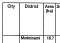
ü@The land readjustment projects planned after this earthquake disaster are provided with various special cases according to "the Hisai Shigaichi Fukko Tokubetsu Sochi-ho(Special Act for Disaster Area)." These project districts are designated as an earthquake disaster rehabilitation land readjustment project district. The main districts are listed in Table 1.
Earthquake disaster rehabilitation land readjustment project:
ü@The earthquake disaster rehabilitation land readjustment project has the following various special cases in addition to the contents of a conventional land readjustment project.
1) Creation of a rehabilitation joint housing district where collective replotting can be executed through an offer made by an owner of a housing site.
2) Provision of housing in or out of the project district instead of account settlement by an executor of the project through an offer made by an owner of a housing site.
3) Securance of land for public infrastructure as a reserved land area.
4) Establishment of a new government subsidy system for a district where a main road is already provided.
5) Relaxation of a district area requirement from 5 ha. to 2 ha.
6) Reduction of a minimum width of a road included in a basic subsidy from 12 m to 8 m (partially to 6 m).
7) Application of special deduction of 50 million yen under the tax system in the case where land is purchased by a local public body or the like before the decision of project planning.
Two-stage designation of land readjustment and redevelopment areas:
|
| Table-1 Main Earthquake disaster rehabilitation land readjustment projects |
|
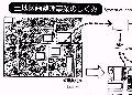
| System of Land Readjustment Project befour after |
backü@indexü@next